
Florida Statewide and Regional ITS Architectures
The Florida District 5 Regional ITS Architecture (RITSA) is a roadmap for transportation systems integration for Florida District 5 services over a 10-year time horizon. The District 5 RITSA has been developed and maintained through a cooperative effort by the state's transportation agencies. The District 5 RITSA complies with the FHWA Rule 940 requirements, as well as the FTA policy directives, for ITS Architectures. The District 5 RITSA was converted to be compatible with the latest version of the Architecture Reference for Cooperative and Intelligent Transportation (ARC-IT) Version 9.3 which makes available all of the ARC-IT content for use in updates to the District 5 RITSA. The District 5 RITSA Conversion Report and the revised District 5 RITSA database are available under the Resource tab.
Change requests received for the District 5 RITSA during the latest Architecture Maintenance cycle have been incorporated in the April 2025 architecture update.
The Statewide and Regional ITS Architectures represent a shared vision of how each agencies' systems will work together in the future, sharing information and resources to provide a safer, more efficient, and more effective transportation system for travelers in the State of Florida.
The District 5 RITSA functionally defines the interactions and information exchanges between the intelligent transportation systems operated and maintained by the various public and private sector organizations in the region. The RITSA includes existing systems as well as planned systems and services that are needed to deliver the transportation services to improve safety, mobility and efficiency across the region.
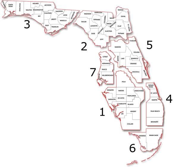
The geographic scope of the District 5 RITSA includes the jurisdictions of public agencies at the FDOT District, Metropolitan Planning Area, County, City, and Town levels. The primary public sector jurisdictional boundaries making up the District 5 RITSA geographic scope include:
The entire District 5 RITSA geographic area is covered by five Metropolitan Planning Organizations (MPO). Covering the five MPOs in the District 5 RITSA makes project integration opportunities more evident and supports coordination among the MPOs as well as state and local agencies for ITS planning and project development.
The District 5 RITSA is adjacent to the District 2 RITSA to the north, the District 7 RITSA to the west, the District 1 RITSA to the southwest, and the District 4/6 RITSA to the south. There are transportation corridors that cross these adjacent RITSAs. District 5 stakeholders, elements, and services that also apply or are used in adjacent RITSAs are consistently defined and referenced. District 5 projects whose applications cross adjacent RITSA borders are defined with services and systems that are consistent in all RITSA to which they apply.
The Florida Statewide ITS Architecture (SITSA) and Florida's Turnpike Enterprise (FTE) RITSA have systems and services that apply across several RITSAs. Like adjacent RITSAs the common systems and services from the SITSA and FTE RITSA are consistently defined in the District 5 RITSA.
The needs, studies and plans of stakeholders in the District 5 RITSA and the adjacent and overlapping architectures were considered when developing the content for the District 5 RITSA and stakeholders' project definition and input.
The District 5 RITSA is used by transportation agencies to define, and by transportation planners to plan, ITS projects that address transportation needs. The RITSA provides a functional framework into which an ITS project is integrated. This framework is used as a reference from which a project is defined. Using the Regional Architecture Development for Intelligent Transportation (RAD-IT) software tool, an agency will choose the transportation services, identify the systems to be included, and then select the information exchanges to tailor the project to address the stakeholders' transportation needs.
The District 5 RITSA, including the defined ITS projects, is used as a reference in transportation planning activities at all levels to coordinate and integrate ITS across the region. Integration opportunities are considered by stakeholders as their projects are defined using the RITSA content as a guide. The RITSA offers a broader picture that the stakeholders take into consideration when thinking of the project definition. The project definitions take into account other systems and services that may be germane to the project scope and future expansion. The projects are defined within the RITSA domain and it is the projects where the integration opportunities are codified. The project definitions in the RITSA are the first opportunity for integration considerations. Project development in further detail in systems engineering is another opportunity. The RITSA is a primary source for those integration opportunities in both cases.
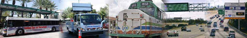
The Statewide and Regional ITS Architectures have a time horizon of ten years with particular focus on those transportation elements likely to be implemented in the next three years. The RITSA covers the broad spectrum of Intelligent Transportation Systems, including Traffic Management, Transit Management, Traveler Information, Maintenance and Construction, Emergency Management, and Archived Data Management over this time horizon. The architecture content supports the quickly emerging and evolving Connected and Automated Vehicle (CAV) environment. CAV presents greater integration and interoperability challenges and the need for institutional cooperation makes the ITS Architecture a valuable tool to discuss and plan these complex implementations.
The purpose of the ITS Architecture web site is to encourage use of the Florida Statewide and Regional ITS architectures, and to gather feedback so that it is used and continues to reflect the intelligent transportation system vision for the state and each district. The menu bar above provides access to the stakeholders, the transportation systems in the region (the "Inventory"), the transportation services that will be provided, transportation-related functions that are envisioned, the existing and planned interfaces in the region, and the "Projects" that are planned for ITS from Stakeholders.
The majority of this web site was generated directly from a Regional Architecture Development for Intelligent Transportation (RAD-IT) software database which defines the architecture for the Florida Statewide ITS Architecture. The source database is also available for download under "Resources" on top, and then "Project Documents".